TimberGuide Pro is an iOS application that allows users to manage timber assets and collect data forms against those assets. Assets are a generic term that includes any natural or man-made features that users need to record information about in the field, such as tracts, stands, treatment areas, pipelines, gates, hunting camps, bridges, culverts and roads. Assets are represented as points, lines or polygons.
A common use case for the TimberGuide Pro application is tracking equipment on forest logging jobs. TimberGuide Pro provides a location logging feature that records a location point (latitude/longitude) every few seconds using the built-in GPS unit on the device. When the device is mounted in the cab of the machine, the machine operator can view their location on the ground relative to the boundary of an imported asset (stand, property, road, etc). Standard base map layers such as satellite view and street view are included by default, but users can also import custom base map layers. All of this combines to give operators and owners additional knowledge about the logging operation. In addition, operators can fill out data forms for assets recording things like time on the job, loads hauled, delivery and destination tickets, and compliance forms.
When used on logging jobs, these location logs are an important piece of the overall picture, as they allow logging contractors and harvest inspection teams to view the progression of the thinning or harvest. Exporting location logs from the TimberGuide Pro database is a straightforward process, and anyone with basic GIS experience can convert the output to feature classes to be used in mapping programs such as ArcGIS Pro or Terrain Navigator Pro. We will discuss this process in more detail next.
Accessing the Location Logs in the TimberGuide Pro Database
The TimberGuide database is used to permanently store information synchronized from the TimberGuide Pro iOS application. This is a cloud hosted database securely stored offsite, but it can be accessed like any other relational database using standard SQL commands and queries. Users with a basic knowledge of SQL can access the location records from the database views and tables and export them to a comma separated text file.
I prefer to use a client application called HeidiSQL to access the database. HeidiSQL is an open source tool that is capable of working with multiple database systems. Users can download HeidiSQL and set up a connection to the TimberGuide database, and run powerful queries in a matter of minutes.
With a SQL client, the following query is used to access all the location logs for the user with an id of 1 in the database.
SELECT * FROM location_logs
WHERE user_id = 1;
Location logs may be queried by user, date, asset name or any other attributes within the location_logs table. For example, the following query would return all logs for user id 1, recorded on November 06, 2019.
SELECT * FROM location_logs
WHERE user_id = 1
AND sequence_time
BETWEEN '2019-11-06' AND '2019-11-07';
The location_log table provides attributes for latitude/longitude, altitude, speed, HDOP, PDOP, heading, and more. After the result set is returned, these logs can be exported from HeidiSQL to a comma-separated text file (CSV).
Below is an example of records from the location log CSV output in tabular form.

After obtaining the output, the next step is to create a point feature layer in ArcGIS. ArcGIS Pro has a tool in the Data Management Toolbox called “XY Table To Point”. Users can run this tool interactively (within ArcGIS Pro) or using Python code in a code window. This tool will create a point feature class (.shp) with one feature for each record in the CSV output table. The resulting feature class will contain every point recorded by the device that was included in the CSV file. This information can be used further to develop summary reports or maps of work progress.
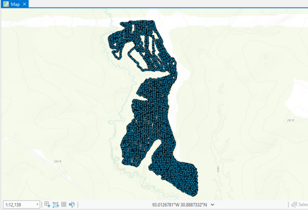
Sample Maps
The following maps show location log points recorded for a mid-rotation ground spraying operation using the TimberGuide Pro application. The first map shows the complete area where the work was performed. The second map shows the same job, but zoomed out to highlight the route our path of the equipment, in this case a skidder.

The final map shows harvest work from a recent logging operation. On this job, TimberGuide Pro is used with an iPad mounted in the cutting machine. This map highlights the work one machine accomplished over a four-day span (color coded by day). Loggers, owners and harvest inspectors can use this information to make better decisions in the field while the job is still active.

Summary
Location logs are just one of the many features included with the TimberGuide Pro iOS application. The process for exporting these logs is fairly simple and straightforward, but some basic knowledge of SQL is useful for creating more advanced queries. Data captured and synchronized by the iOS device is stored in a secure cloud database offsite.
Loggers, harvest supervisors, and foresters can use the location logs to track harvest progress, daily production, and to identify SMZ boundaries and other natural features on the ground. These logs are also useful for documentation purposes during audits and for evaluating harvest decisions such as set, road and skid trail placement.
For more information on the TimberGuide Pro iOS application, please visit the Catenaut TimberGuide Pro webpage.
Categories: Forestry Apps

Leave a comment