One of the fastest growing geospatial technologies is commercial satellite imagery (source). The quality of commercial satellite imagery is getting better, and the acquisition cost is getting cheaper due to increased competition in this industry. Forestry operations that require accurate maps of harvest areas, stockpiles, or land-use change detection analysis, can benefit from the lower relative cost of satellite imagery compared to other mapping technologies. In this article, we will consider how these technologies compare in terms of acquisition cost and processing time.
Cost Relative to Other Mapping Solutions
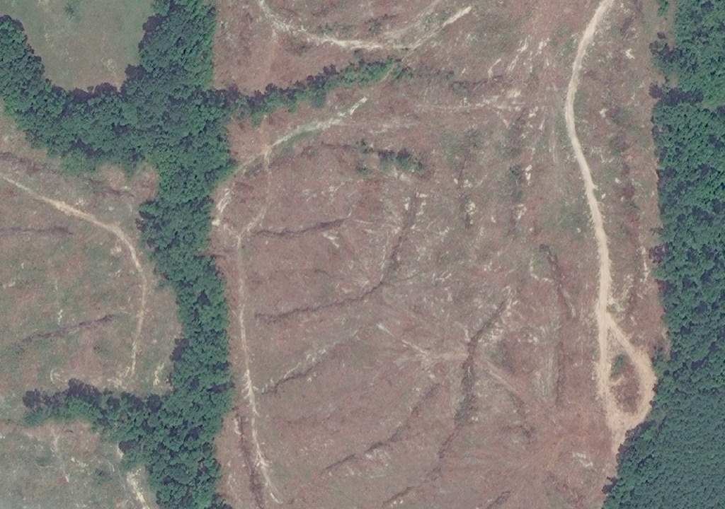
The image shown above was a 2km x 2km archive image of an area that was recently clearcut and mechanically site prepared. The cost of this image was $80.00, and the total harvest area was 167 acres. For about 30 minutes of work, I was able to download, import and digitize this area for $0.48 per acre. Add another $0.30 per acre for my time, and the total cost comes to $0.78 per acre.
Several months ago, I posted an article on LinkedIn called “Mapping Timber Harvests Using Recent Satellite Imagery“. In that article, I discussed the cost of mapping a forest clearcut using newly acquired archive image. The total cost given in the example for that article was roughly $0.60 per acre for a non-georeferenced image. The georeferenced version (GEOTIFF) would have doubled the cost per acre ($1.22 versus $0.60), but would have reduced the processing time significantly. This is still impressive for a 40 cm resolution image considering that the area of interest was only 68 acres, versus 167 above.
An obvious take-away from these examples is that the final cost depends heavily on the size of the harvest area being mapped. The smallest archive image available for purchase is 2km x 2km for $80 (georeferenced). So my goal is always to get as many acres crammed into this 2×2 square as possible. The image retailer can help you position these images relative to your area of interest to maximize the area covered by the image.
Option 1 – Aerial imagery taken by fixed-wing aircraft
Let’s compare that cost with the cost of hiring a company to take aerial images of the harvest, which would have been considerably higher. Also, consider the fact that the subject property was only 68 acres. I believe it would have been difficult, if not impossible, to get an aerial company to contract this small property. Honestly, I have no idea what this solution would have cost, but I’m guessing between $1.50 to $2.00 per acre.
Larger timber companies (TIMOs and REITs) with many harvests in a region, can take advantage of scale and get the cost much lower. But even then, I’m not sure that they can get the cost below $1.00 per acre for comparable aerial imagery. If they can, then more power to them.
Option 2 – UAV (drone) imagery
Next, let’s consider the cost of UAV collected imagery. When you calculate the cost of hiring a UAV service, or a do-it-yourself option (factoring in your field and processing time), I’d be really shocked if this was a cheaper solution. A few years ago, I worked with a company that purchased company UAVs to map forest clearcuts. Each year it was around three to four thousand acres on average. I don’t recall their actual cost, or if they even could calculate it, but I think it was somewhere above $4.00 per acre at that time.
Option 3 – Mapping with a handheld GPS unit
Lastly, let’s consider the dependable method of walking a harvest area with a GPS unit. Personally, I have a lot of experience with this method of mapping harvest areas. I have a dataset with over 7500 hours of GPS work conducted on 51,000 acres of clearcuts over the past 10 years. The average cost for this method from my data, is $4.60 per acre.
Final Thoughts
I hope I’ve made the case for using satellite imagery as a lower cost solution for mapping harvest areas. Granted, this example has only considered archive satellite imagery, which may not be available within the timeframe needed or for your area of interest. I’ve successfully found archive imagery from as recent as a few days post-harvest to three months post-harvest. To date, I’ve purchased around 35 images, and have mapped thousands of acres of forestland. If you would like to know more about the source of this imagery please visit Catenaut’s Satellite Imagery page.
Categories: Satellite Imagery

Leave a comment