If you work in a Forestry Profession, by now you’ve likely heard the term Geographic Information System (a.k.a.; GIS), and hopefully you already have some experience using one. Maybe you have an interest in learning how GIS can help your organization, but aren’t interested in breaking your budget. Well your in luck! There are several good software options available that are ideal for managing geospatial information. In this post, I explain how GIS software can benefit a Forestry organization, and explain some of the software that I use often for this purpose.
How can GIS benefit a Forestry Organization?
The principal component of GIS is geographic data, and storing, visualizing and transforming data into usable information is its primary purpose. In most cases this involves working with a database, or file-based data storage format such as SHP, JSON, GPX, or KML. As technology improves, geospatial data becomes increasingly more valuable to the organization.
Forest management companies often keep detailed records of management activities, such as harvesting, silviculture, and property improvements. Foresters, timber buyers, and loggers frequently need to make informed decisions about what to harvest, when to harvest, and where to harvest timber. These decisions are supported by documentation such as maps, historical records, contracts or harvest plans. GIS software can help maintain forest records, as well as provide a robust mapping interface complete with tools for working with data. Geospatial records and attributes can be used to create additional data products such as maps, management reports and dashboards. In addition, they can be stored for long periods of time to comply with regulatory or fiduciary requirements.
Mapping is an essential task in many forestry organizations. Activities in, on, and around the forest require maps for location, clarity, and proximity. Paper-based maps are becoming less common, and are frequently replaced with digital formats that are easier to store, transfer, and display. Key features of a robust mapping platform include import, export and transforming geospatial data into multiple formats for use in making map based products.
Next, we will discuss some affordable GIS mapping software.
Affordable GIS Software
QGIS

QGIS (https://qgis.org/en/site/) is my personal choice for a fast, robust GIS, and is capable of more functionality than most Foresters need. I use this program quite often, for a multitude of projects such as mapping, imagery processing, and geographic transformations.
QGIS is an Open Source software platform offered under the GNU General Public License, which means you are free to download and use it for any purpose. It runs on Windows, Mac, Linux, and Unix devices, which is a real plus in my opinion.
QGIS works with many vector file formats including SHP, KML, and GPX, and rater formats including GeoTIFF and JPEG. QGIS supports many advanced features such as topologies, PostGIS enabled database functions, and spatial analysis. It also has a rich set of Coordinate Reference Systems (CRS) for transforming vector and raster files. Another nice feature is that QGIS supports community built plugins for added functionality.
QGIS is an excellent piece of software, for a robust, flexible GIS, that can handle most, if not all, Forestry related tasks.
Terrain Navigator Pro
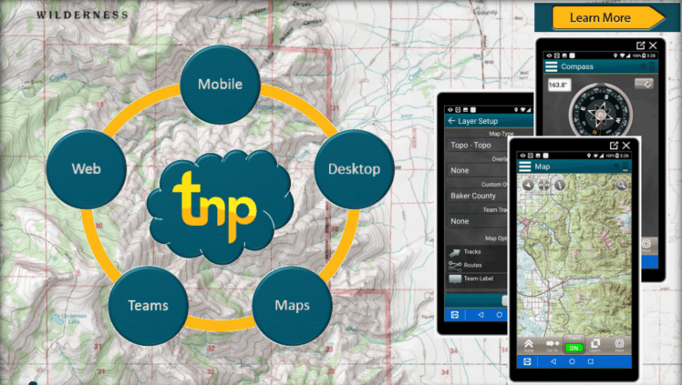
Terrain Navigator Pro (TNP) by Trimble (https://www.terrainnavigator.com), is not technically GIS software, but a robust mapping platform that can perform many forestry related tasks. It has a rich set of features and works with many common file formats. One of my favorite features about this software is that it has a mobile platform for working with projects in the field.
TNP’s complementary mobile app can be taken to the woods and the data collected automatically syncs back to the desktop version using a mobile network connection. The TNP mobile app can also be used in offline-mode for working in remote areas without a network connection. The mobile app works on iOS and Android devices.
TNP has many features that complement the field forester, and can provide a multi-user mode when working in teams. In a multi-user environment the team collected data is synchronized across your team devices, when you have a network connection (wifi or cellular). This feature is automatically available when two or more licenses are purchased.
TNP has a retail price of $280 per license per year. There is an optional Ownership add-on which provides recent tax assessor parcel information for your state, and an optional Sites add-on for working with CAD designs and high resolution imagery. These add-ons are an additional $180 per user per year.
For under $500 per year TNP offers a rich set of features and tools for creating maps and working with GIS data.
ArcGIS Pro
ESRI ArcGIS* is a household name in GIS software. ESRI has a long-standing reputation for providing quality software products and tools that complement Forestry. Prior to the release of ArcGIS Pro, ESRI’s primary single-license product was ArcGIS Desktop software starting at $1500 per user license for the Basic version. Now with ArcGIS Pro you can get similar functionality that comes with the Basic Desktop software for around $700 per year.
I have used ArcGIS Desktop for just over 10 years, and ArcGIS Pro for the last year. I have grown fond of ArcGIS Pro and use it more frequently now than the Desktop version. ArcGIS Pro is a full-featured product that is capable of providing Forestry organizations with advanced GIS functionality they require. As an added benefit with a Pro subscription you get an ArcGIS Online Account for hosting GIS data online, as well as access to many of the mobile apps available from ESRI. Overall, this is a really good option for small to medium-sized businesses who are interested in getting started with or have experience with a GIS platform.
Final Thoughts
In this post we have learned how a GIS can help a forestry organization and discussed some examples of software that are available for under $1000 per year. These GIS tools are increasingly becoming more powerful and able to provide mapping and analysis functions at a reduced cost. Even if you are a novice to GIS, I estimate you can be up and running with these tools in as little as one week’s time.
*ArcGIS is a Trademark of ESRI (Environmental Systems Research Institute, Inc)
Categories: Forestry Apps

Leave a comment